A ship chart is an essential navigation tool that helps mariners understand the waters they travel through. Similar to a road map for land transportation, a nautical chart provides important information about coastlines, water depths, navigation markers, underwater hazards, and shipping channels. It helps sailors plan routes, determine positions, and navigate safely between ports and destinations.
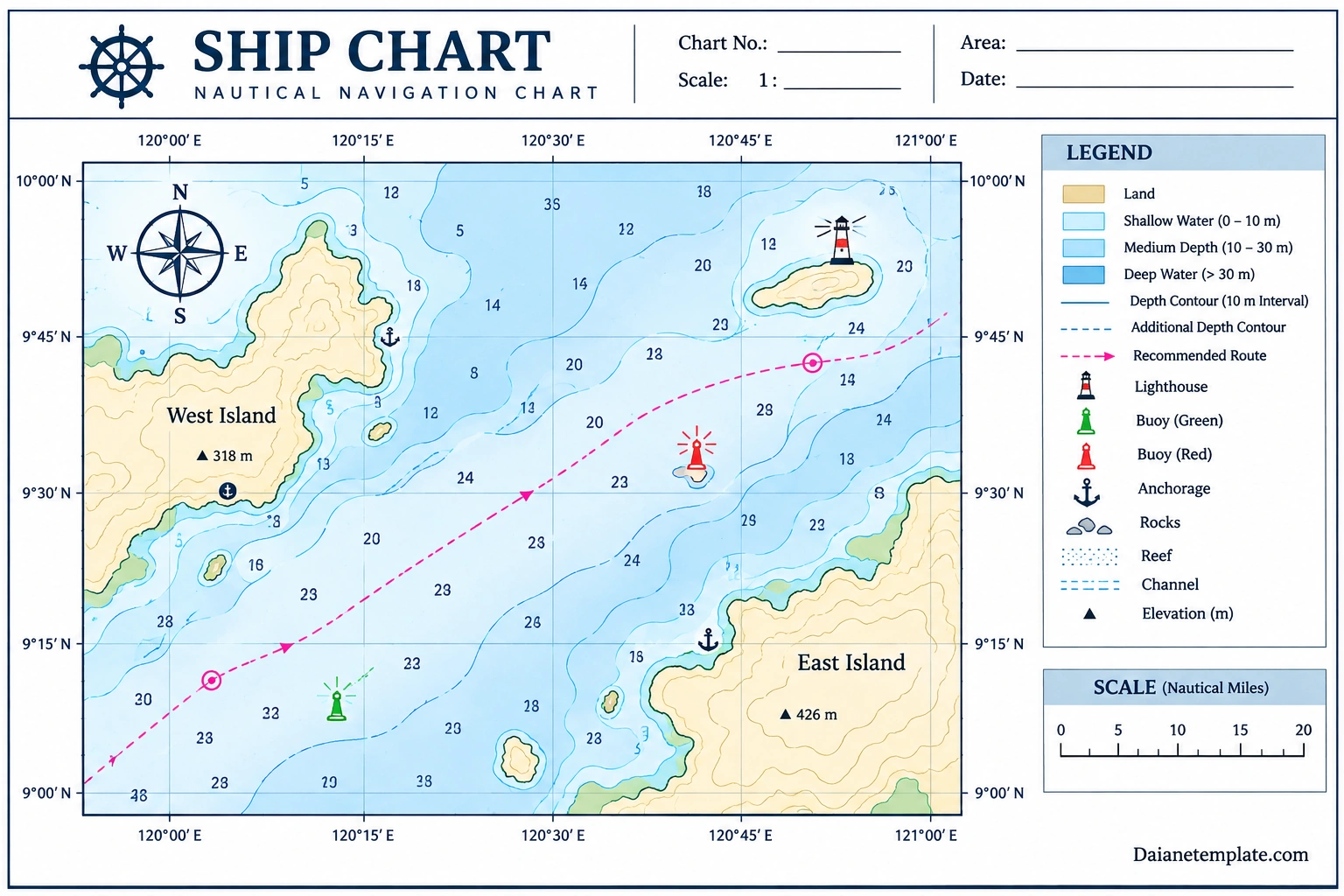
Whether used on commercial vessels, fishing boats, or recreational sailboats, a reliable ship chart supports informed navigation decisions. It allows mariners to identify shallow areas, locate safe passages, recognize navigational aids, and understand the underwater features that may affect a vessel’s movement.
Modern marine navigation uses both traditional paper charts and electronic chart systems. Although their formats differ, both provide geographic and navigational information that helps crews understand their surroundings. This guide explains what a ship chart is, the information it contains, common chart symbols, and how mariners use nautical charts during voyage planning.
What Is a Ship Chart?
A ship chart, commonly called a nautical chart, is a specialized map designed to support navigation on oceans, seas, rivers, lakes, and other navigable waterways. It presents geographic information and marine navigation details that help vessels travel while avoiding dangerous areas.
Unlike ordinary maps, nautical charts include information specifically relevant to navigation. They may show water depths, seabed characteristics, coastlines, underwater obstructions, navigational aids, and locations where vessels can safely anchor.
Mariners use nautical charts for several important activities:
- Voyage planning: Selecting routes between departure points and destinations.
- Position fixing: Identifying a vessel’s location using coordinates and recognizable geographic features.
- Hazard avoidance: Identifying shallow water, reefs, rocks, wrecks, and other potential dangers.
- Route monitoring: Comparing the vessel’s actual position with its intended course.
- Port approach: Understanding channels, harbor entrances, anchorages, and nearby navigation markers.
A nautical chart is therefore more than a map of the coastline. It is a detailed navigation reference that supports safer and more efficient marine travel.
Why Are Ship Charts Important for Marine Navigation?
Marine environments can change significantly over relatively short distances. Water depth, tides, currents, underwater obstacles, and coastal geography can all affect a vessel’s route. A ship chart helps mariners understand these conditions before and during a voyage.
1. Helps Prevent Grounding
Grounding occurs when a vessel unintentionally touches the seabed or another underwater obstruction. This can damage the hull, affect propulsion systems, and create serious safety risks.
Depth information and underwater hazard markings help mariners identify areas that may be too shallow for their vessel. However, safe passage also depends on draft, tide levels, vessel movement, and current chart information.
2. Supports Accurate Route Planning
Before departure, navigators use nautical charts to examine possible routes, identify suitable passages, and determine areas that require additional attention.
They may consider:
- Water depth along the intended route.
- Nearby islands, reefs, and underwater obstructions.
- Shipping channels and traffic separation schemes.
- Available anchorages and harbor entrances.
- Navigation aids and recognizable coastal features.
- Weather, tides, currents, and other environmental conditions.
3. Improves Position Awareness
Coordinates and geographic features help navigators determine where a vessel is located. When combined with appropriate positioning equipment and other navigation methods, a chart helps the crew compare the vessel’s position with the planned route.
4. Helps Identify Navigational Hazards
Reefs, rocks, wrecks, shallow areas, and restricted zones can create significant risks. Nautical charts use symbols, labels, and depth information to identify many of these features.
5. Supports Safe Harbor Approaches
Approaching a harbor can require careful navigation through narrow channels, shallow areas, and marked passages. A detailed chart helps mariners understand the layout of the approach and identify relevant navigation markers.
What Information Does a Ship Chart Contain?
A ship chart combines several types of geographic and navigational information. Understanding these elements makes it easier to interpret the chart and recognize important features.
1. Water Depth and Soundings
Water depth is one of the most important details on a nautical chart. Depth values, often called soundings, indicate the measured or charted depth at particular locations.
These measurements help navigators evaluate whether a waterway is suitable for a vessel. The chart should also identify its depth units and the reference level, or chart datum, used for the soundings.
2. Depth Contours
Depth contours are lines connecting locations with the same water depth. They help mariners understand how the seabed changes across an area.
Closely spaced contours may indicate a relatively steep change in depth, while widely spaced contours can suggest a more gradual seabed slope. These lines are useful for identifying underwater terrain and changes in water depth.
3. Coastlines and Land Features
Nautical charts show coastlines, islands, beaches, headlands, and other geographic features. These details help navigators recognize their surroundings and understand the relationship between land and navigable water.
4. Latitude and Longitude
Latitude and longitude provide a geographic coordinate system for identifying positions on Earth. Latitude measures distance north or south of the equator, while longitude measures distance east or west of the prime meridian.
Coordinate markings around a chart help navigators identify locations, plot positions, and measure geographic distances.
5. Navigational Aids
Navigation aids help mariners identify channels, hazards, and important locations. Common examples include:
- Lighthouses and lighted beacons.
- Buoys and floating markers.
- Daymarks and fixed navigation structures.
- Leading lines and ranges.
- Radio navigation reference points.
The meaning of each marker depends on its characteristics, location, and the applicable buoyage system.
6. Underwater Hazards
A ship chart may identify reefs, rocks, wrecks, obstructions, and other underwater features. These markings are important because hazards may not be visible from the surface.
7. Compass Rose and Direction
A compass rose provides directional reference, including north, south, east, and west. Nautical charts may also provide information about magnetic variation and other directional references relevant to navigation.
Common Ship Chart Symbols and Their Meanings
Nautical charts use standardized symbols and abbreviations to communicate information efficiently. These markings allow mariners to identify important features without relying on lengthy descriptions.
Common chart symbols and features include:
- Depth soundings: Numbers showing charted water depths.
- Depth contours: Lines connecting areas of equal depth.
- Land areas: Shaded or colored regions representing coastlines and islands.
- Lighthouse symbols: Mark the location of navigational lights.
- Buoy symbols: Show floating navigation markers.
- Anchor symbols: Identify anchorage areas or anchor-related features.
- Reef symbols: Indicate coral reefs or other shallow underwater hazards.
- Wreck symbols: Identify recorded sunken vessels or wreck locations.
- Channel markings: Identify designated or maintained navigation passages.
Symbols and abbreviations can vary according to chart standards and the issuing authority. Always consult the chart legend and the relevant official chart reference instead of relying on memory or a generic illustration.
Types of Ship Charts
Different nautical charts are designed for different navigation needs. The appropriate chart depends on the vessel, voyage, geographic area, and level of detail required.
1. General Charts
General charts provide a broad overview of large geographic areas. They are useful for understanding major coastal regions and planning longer passages.
2. Coastal Charts
Coastal charts provide more detailed information about coastlines, islands, navigation aids, and water depths. They support navigation along coastlines and between nearby ports.
3. Harbor Charts
Harbor charts focus on ports, marinas, harbor entrances, and nearby waterways. Their greater level of detail helps mariners navigate confined waters and identify local navigation features.
4. Electronic Navigational Charts
Electronic Navigational Charts, commonly called ENCs, are official digital chart datasets designed for use with compatible electronic chart systems. They can display geographic features, depth information, navigation aids, and other charted details.
When used with an approved Electronic Chart Display and Information System (ECDIS), official ENCs support electronic navigation in accordance with applicable requirements.
5. Raster Nautical Charts
Raster charts are digital images of paper charts. They preserve the visual appearance of the original chart but do not contain the same structured geographic data as an ENC.
They may be useful in certain navigation applications, but mariners should understand their limitations and follow applicable carriage and navigation requirements.
How to Read a Ship Chart
Reading a nautical chart requires attention to its scale, legend, depth information, coordinate system, and navigation symbols. The following steps provide a basic introduction.
Step 1: Check the Chart Title and Coverage
Start by checking the chart title, geographic coverage, issuing authority, edition information, and publication details. Confirm that the chart covers the area relevant to your voyage.
Step 2: Understand the Chart Scale
The scale indicates the relationship between distances on the chart and actual distances on Earth. A large-scale chart provides more detail over a smaller area, while a small-scale chart covers a larger geographic region with less detail.
Use the appropriate chart scale for the navigation task. Harbor approaches generally require more detailed coverage than broad ocean passage planning.
Step 3: Read the Chart Legend
Review the legend before interpreting symbols. It explains the meaning of chart markings, abbreviations, colors, and navigation features.
Step 4: Examine Water Depths
Identify soundings and depth contours along the intended route. Consider the vessel’s draft, under-keel clearance requirements, tide conditions, and other relevant safety factors.
Step 5: Identify Navigation Aids and Hazards
Locate buoys, lighthouses, channels, reefs, rocks, and wrecks. Pay particular attention to hazards near narrow passages and coastal approaches.
Step 6: Review Coordinates and Directions
Use latitude and longitude markings to identify positions. Check the chart’s directional references and understand the difference between true north and magnetic north when relevant.
Step 7: Verify Chart Updates
Before using a chart for navigation, check its edition and update status. Important changes may include new hazards, revised depths, altered navigation aids, or changes to channel information.
Paper Ship Charts vs. Electronic Nautical Charts
Both paper and electronic charts provide marine navigation information, but they differ in how information is presented and used.
Paper Nautical Charts
Paper charts provide a physical reference that can be reviewed without electronic display equipment. They are useful for route planning, visual reference, and backup navigation procedures.
However, paper charts require manual plotting and careful attention to corrections and updates.
Electronic Nautical Charts
Electronic charts can display vessel position, route information, and selected navigation details through compatible equipment. Depending on the system and chart type, they may also support route monitoring and additional navigation functions.
Electronic systems still require correct configuration, updated chart data, equipment checks, and competent interpretation. A digital display does not eliminate the need for navigation knowledge or independent verification.
Tips for Using Ship Charts Safely
Using a nautical chart correctly requires more than identifying symbols. Mariners should combine chart information with other navigation resources and maintain awareness of changing conditions.
- Use appropriate official charts: Select charts issued or recognized by the relevant hydrographic authority.
- Check the latest updates: Review Notices to Mariners and other official corrections.
- Understand chart datum: Know the reference level used for depths and relevant tidal information.
- Consider vessel draft: Evaluate water depth and required under-keel clearance.
- Review weather and tides: Conditions can affect safe passage and route selection.
- Use multiple navigation methods: Do not rely on a single display or positioning source.
- Study the chart legend: Confirm the meaning of unfamiliar symbols and abbreviations.
- Maintain a backup plan: Be prepared for equipment failure or changes in navigation conditions.
Frequently Asked Questions About Ship Charts
What is a ship chart used for?
A ship chart is used for marine navigation. It provides information about water depths, coastlines, navigation aids, underwater hazards, and geographic coordinates to support route planning and safe vessel movement.
Is a ship chart the same as a nautical chart?
Yes. The term ship chart is commonly used to describe a nautical chart, which is a specialized map designed for navigation on navigable waters.
What information can you find on a nautical chart?
A nautical chart can show water depths, depth contours, coastlines, islands, latitude and longitude, navigation markers, lighthouses, reefs, wrecks, anchorages, and other marine features.
What do numbers on a ship chart mean?
Many numbers on a nautical chart represent water depths, although other numbers may identify geographic coordinates or chart features. Always check the chart’s units, notes, and legend to interpret them correctly.
What is the difference between a large-scale and small-scale nautical chart?
A large-scale chart shows a smaller geographic area with greater detail. A small-scale chart covers a larger area with less detail. Large-scale charts are generally useful for detailed coastal and harbor navigation.
What is an Electronic Navigational Chart?
An Electronic Navigational Chart, or ENC, is an official digital chart dataset used with compatible navigation systems. It contains structured geographic information that supports electronic chart display and navigation functions.
How often should nautical charts be updated?
Charts should be checked and updated according to the issuing authority’s correction procedures and the latest official information. The frequency depends on the chart, geographic area, and changes to navigational conditions.
Can a ship navigate using only an electronic chart?
Navigation requirements depend on vessel type, operating area, and applicable regulations. Approved electronic systems may satisfy certain chart carriage requirements, but vessels must follow relevant rules and maintain appropriate backup arrangements.
What is a compass rose on a nautical chart?
A compass rose is a directional reference printed on a chart. It shows compass directions and may include information relevant to true and magnetic bearings.
Where can I find official nautical charts?
Official nautical charts are available through authorized hydrographic offices and approved chart distributors. Mariners should use current products from the relevant national or regional authority for the waters they intend to navigate.
Final Thoughts
A ship chart is an essential reference for understanding marine geography and planning safe vessel movements. By showing water depths, coastlines, navigation aids, underwater hazards, and geographic coordinates, it helps mariners make informed decisions throughout a voyage.
Understanding chart scales, symbols, depth contours, and coordinate markings makes nautical charts easier to interpret. However, safe navigation also requires current chart information, appropriate equipment, knowledge of tides and weather, and sound seamanship.
Whether using a traditional paper chart or an electronic navigation system, mariners should always rely on appropriate official and up-to-date information. A nautical chart is a valuable navigation tool, but it must be used together with other safety procedures and professional judgment.
Download: Ship Chart Template
